Author: Greg Jeffries, CUC, M.ASCE | ©March 2025 | All Copyrights Reserved
There has been a lot of discussion lately around Artificial Intelligence (AI), and the role it plays, or can play in our lives and professions. Emerging technologies, particularly Artificial Intelligence (AI) is looking to transform how we locate and map buried utilities. This article explores how AI-derived data integrates with the ASCE 38-22 Standard Guideline for Investigating and Documenting Existing Utilities, focusing on the implications for Quality Level D (QLD), professional judgment, liability, and the need for rigorous documentation. Insights from technology leaders and practicing professionals frame a cautious but forward-looking approach to incorporating AI into SUE practice.
AI is rapidly expanding its influence in many professional domains, including civil and utility engineering. One of the uses for AI is within my professional specialty, Subsurface Utility Engineering & Investigation, or utility investigation more broadly. Among its emerging applications is the use of AI to locate, infer, and depict buried utilities, tasks traditionally performed by utility engineers through records research, and field surveys. With the growing availability of digital utility records, historical maps, and satellite imagery, AI offers promising capabilities to consolidate data and suggest utility locations. As this technology advances, a pressing question emerges: can AI-derived data meet the standards of utility investigation as defined by ASCE 38-22? This article evaluates that question through the lens of Quality Level D (QLD), examines the role of the Utility Professional, and provides guidance for responsibly integrating AI into the SUE process.
While many companies and individuals are exploring various aspects of AI, notable among these are:
- 4M Analytics: Uses AI to synthesize massive utility record datasets, satellite imagery, and publicly sourced data to deliver a utility map meant to support early project planning.
- Exodigo: Combines multi-sensor geophysical data (GPR, EM, magnetics) with AI algorithms to locate and identify underground utilities without excavation.
- Reveal: Integrates utility survey data and geophysical detection into a model that is AI-processed for pattern recognition and utility inference.
Each of these entities offers technology that provides insight into utility information through AI-driven analysis of information to derive a report of likely or potentially existing utility placements. These representations are often presented as meeting or approximating QLD—but can they truly be adjudged as such under ASCE 38-22? Though I have some familiarity with the process in general, I will not pretend to know exactly how these providers apply their methodologies, processes, or algorithms, so I have reached out to each for some insight for this article.
In the broad sense, and likely grossly oversimplified, the AI-derived utility information is compiled from multiple sources to deliver a singular report of the information. As I understand the process, the information sources include information gathered from Geospatial Information Systems (GIS), as-built or as-constructed plans, utility records, utility atlases, records of previous utility investigation efforts, permit databases, satellite imagery (i.e., Google Earth, Bing, etc.), and even publicly sourced imagery (public photos, CCTV images, etc.). These disparate data sources are then geo-aligned or geo-referenced and amalgamated, layered, and conflated, through one or more algorithms to determine the likely position of the existing utilities in a given area. The output is then delivered in various formats (CADD, Shapefile, KMZ, etc.) for consumption by the requesting party. This is where the subject gets interesting, and the questions start arising.
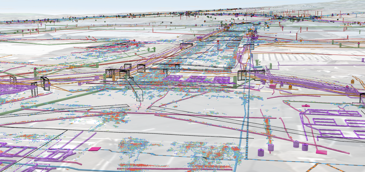
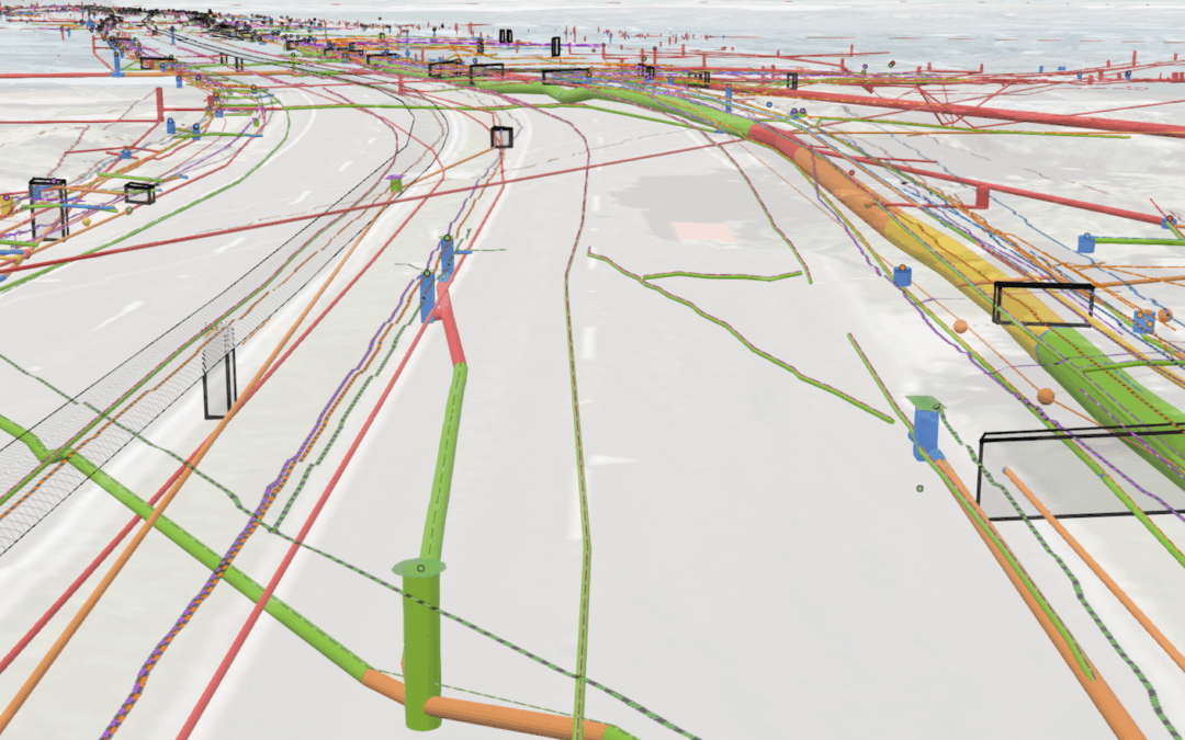
Figure 2, AI-Enhanced Utility Imagery – Reveal
Before jumping into the questions, it is important first to discuss the standard we recognize for depicting utility information, the ASCE/UESI/CI 38-22 Standard Guideline for Investigating and Documenting Existing Utilities. “Endeavors to safeguard public welfare by providing guidance on performing utility investigations and documenting results in a standardized fashion. It serves as both a prescriptive standard and a performance standard. As a prescriptive standard, it provides a series of minimum actions necessary to achieve utility quality level documentation. As a performance standard, it describes the professional judgment necessary to determine the appropriate timing, sequencing, location, and scope of a utility investigative effort” (ANSI webstore, 2025). The ASCE 38 standard presents a credible system for classifying the quality of utility location information that is placed in design plans. The quality levels for documenting existing utilities are Quality Level D (QLD), Quality Level C (QLC), Quality Level B (QLB), and Quality Level A (QLA). These quality levels are probably most easily understood in terms of traditional grammar school letter grades, with D being the lowest passing grade, and A being the highest passing grade.
Of course, this is a basic simplification of the quality levels, but it does reasonably summarize the point. If you are depicting existing utility information on a set of construction plans, such information as adjudged by the utility professional to be QLD would be the lowest grade of information acceptable. This does not mean that the depicted information is correct, it merely indicates that an effort was made to identify the existing utilities within the project scope, through researching available utility records and qualifying their relevance to the project scope and limits. QLD information is not understood to be sufficient to design an invasive construction project, it is a foundation to guide additional investigation through the application of engineering survey and geophysical instruments.
ASCE 38-22 defines QLD as follows: “A value assigned to a Utility Segment or Utility Feature not visible at the ground surface whose estimated position is judged through Utility records information from others, or from visual clues such as pavement cuts, obvious trenches or existence of service.”. The Utility Professional for the project may assign QLD to utility attributes, segments or features after review and compilation of existing records, oral recollections, One Call or “private locate” markings, managed data repositories in context with other achieved Utility Quality Levels, and/or other evidence of existence. QLD data is more uncertain than QLC, QLB, and QLA. QLD data is less uncertain than utilities documented without any Utility Quality Level barring a Professional’s statement of fact to the contrary” (ASCE/UESI/CI 38-22 – Standard Guideline for investigating and Documenting Existing Utilities, 2022).
Using this tiered system, project designers can manage risk: for instance, they might rely on QLD for an initial project analysis, QLC and utility feature surveys for a more significant review, and QLB data for more specific planning, and perform QLA test holes at key conflict points. ASCE 38-22 not only defines these levels but also gives a more prescriptive process for achieving them than the previous standard (ASCE 38-02), emphasizing thorough documentation and professional oversight. Now that we have defined the standard by which this data is judged, we need to determine if the AI-derived data meets the QLD standard, or if it can be adjudged by the Utility Professional to achieve this level. One of the key elements is data sources and the chain of custody for the data utilized to provide the AI-derived output. The Utility Professional should insist that the AI platform provides references for the data. For example, if a line appears on the AI map, there should be metadata like “sourced from City Water GIS (2020)” or “inferred from 1985 aerial photo showing utility cut”. Without this, the professional cannot assess reliability. ASCE 38-22 QLD allows info from “other sources”, but it also states that QL-D data is uncertain and must be vetted. Knowing the pedigree of each piece of data is part of that vetting. Utility Professionals must question what they cannot control. Since AI algorithms are often proprietary and opaque, there is an inherent limit to how confidently one can verify their outputs without direct access to their logic or training data.
AI technologies can assist subsurface utility engineering in many ways, from identifying utility indicators in images to interpreting remote-sensing data and consolidating information into representative maps. In short, AI excels at recognizing patterns in large or complex data sets. Obviously, such an ability can be well-suited to the challenges of finding utilities hidden underground. The data derived from the AI sources is potentially very good information and may indicate the presence of previously unknown, or undocumented facilities.
An AI-driven system can take inputs like old utility records, GIS data, surface survey and feature data, and pieces of geophysical investigation results, and use interpolative reasoning or machine learning to predict where unobserved utility lines are likely to run. The AI system looks at patterns, the algorithms can be trained to detect manhole covers, fire hydrants, valve boxes, utility poles, and other surface appurtenances that indicate the presence of subsurface infrastructure, cross-references details like pipeline routes, cable markings, and historical plans, and fill in gaps to propose an AI-derived map of underground facilities. A major challenge is the lack of large, vetted datasets for training the AI systems. As Utility Professionals know, real-world underground scenarios are infinitely variable. AI models trained on limited data sets may not perform well where there is significant variations in surface types or where a large variation of utility types exist.
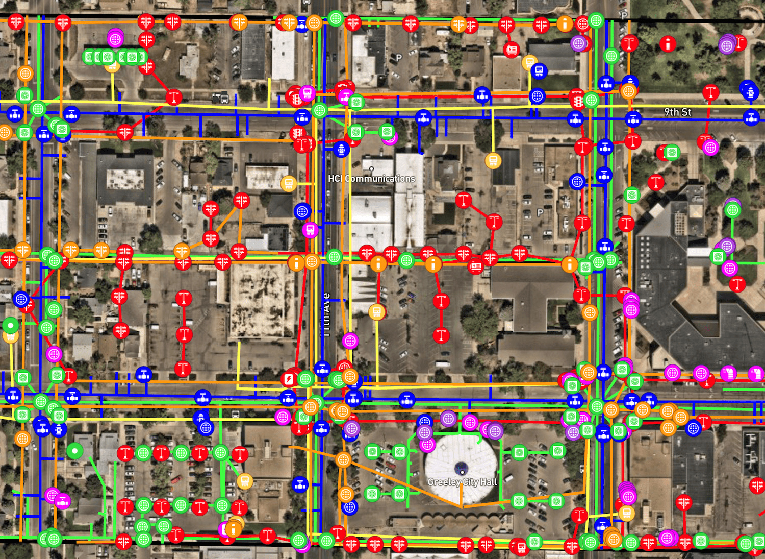
Figure 3, AI-Derived Utility Data – 4M Analytics
One of the issues encountered is, in some instances, AI-derived utility data has been represented as QLD information. This could not be further from the truth. While AI is a powerful tool, it is not a magic solution and must be viewed within the framework of prudent and professional engineering practice. Utility record data received or obtained for a project is not automatically QLD data, neither is AI-derived utility data. Such data received for a project must be scrutinized to ensure relevance to the project, to ensure it is within the project limits, within the ROW or specific design limits, and is representative of utilities that could reasonably be presumed to exist within the project scope. AI-derived utility data may indeed meet the coverage/limit criteria, but this does not mean that it achieves QLD. It is important to reiterate that a QLD assignment is a judgment of the Utility Professional that the data meets the criteria for assignment.
Subsurface utility engineering deals with public safety and potentially significant liability, so any AI-generated results must be treated with appropriate scrutiny. AI will not replace the need for experienced utility engineers and geophysicists. The Utility Professional remains responsible for the final utility maps and any decisions made as a result of the mapping efforts. AI-derived data may prove valuable for analysis, but it cannot be permitted to make autonomous decisions. The Utility Professional must determine the value of the AI-derived data and adjudge any quality level of that data. When incorporating AI-derived data, professional oversight is mandatory. AI companies might generate utility maps, but unless a qualified SUE provider is vetting and signing off on that information, it does not meet the standard of any quality level. If utility data lacks the involvement and analysis of licensed engineers/surveyors, it cannot be considered reliable under the ASCE 38-22 standard, thereby leaving clients at legal risk. In other words, no matter how advanced an AI tool is, its results must be reviewed and stamped by a Utility Professional for those results to carry the weight of a true SUE deliverable.
Professionals should view AI as an aid that can handle repetitive tasks or suggest insights, while the Utility Professional in charge must interpret and validate those insights. Ultimately, the engineer’s seal on a deliverable means they take accountability for accuracy, regardless of whether AI was used to produce it. And therein lies another issue; the Professional does not control the algorithms used by the AI system. How can the professional truly determine the validity of the AI-derived data if its creation is outside of the professional’s control? Notably, ASCE 38-22 places specific emphasis on documentation and professional oversight throughout the SUE process. Each utility depiction should trace back to how that information was obtained, and the professional responsible for certifying said SUE results. This provides accountability – if a utility’s location is shown as QLD, there should be a corresponding record that depicts the utility information shown, essentially the data provenance. Record data assembled and adjudged at QLD by a Utility Professional involves recording where each piece of information came from and determining its reliability. AI must be held to the same standard. One interesting aspect of ASCE 38 is the inclusion of oral recollections in QLD data, like asking a tenured employee about past utility work. AI cannot obtain such recollections. Capturing those inputs and adding them to the record with notes on who said it and when is part of chain of custody. For instance, if a utility is shown at QLB, a record of the geophysical investigation and survey that determined the utility position should be maintained and a qualified professional must stand behind that data’s accuracy.
Another concern is the data foundation for the AI model. AI-derived data is only as reliable as the data it learns from and works with. If the input data is inaccurate or biased, the AI’s output will reflect those flaws. Under ASCE 38-22, documentation of existing utilities must be scrutinized and verified; similarly, any data that an AI system uses should go through a regimented quality control process. Since these sources and algorithms are outside of the direct oversight and control of the Utility Professional, how can it be adjudged or assigned a quality level? To this end, AI-derived data should likely be considered as an information tool. There has been discussion of indicating a separate quality level for AI-derived data, however, doing so would provide immediate legitimacy to an as-yet unproven process. AI-derived utility data should be specifically tagged to ensure it is not confused with data derived from more traditional methods. It should remain incumbent on the professional in charge to determine the relevancy and applicability of AI-derived utility data and determine if it can be assigned a quality level. Providing a separate quality level for AI-derived data that absolves the professional from any associated liability would open the door to broad inclusion without vetting. Since the AI-derived data is outside of the direct control of the professional, it would require additional focus and scrutiny by the professional before inclusion in any deliverable.
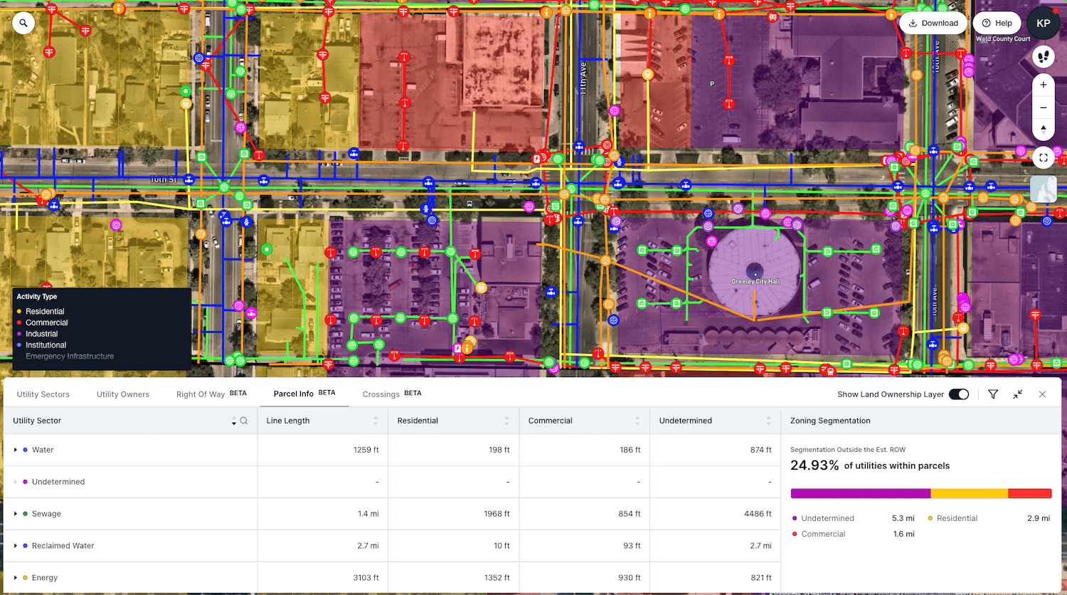
Figure 4 AI-Derived Data Analysis – 4M Analytics
While discussing these points with Itzak Malka, Co-founder and CEO of 4M Analytics, he noted two critical concerns, “One concerns the way we deal with the abundance and absence of observable data, and the other concerns the profession of SUE and how AI can fit within that world.”. Both concerns seem to evoke a common theme and were similarly noted in discussions with Reveal. Itzik addressed the former concern by looking at AI as a “method to unlock a massive abundance of data that historically was unavailable for observation, even when putting boots on the ground”. Indeed, SUE data is likely best analyzed in total by experts visiting the project site in person with all available data in hand.
Current examples of AI-derived data likely incorporates, and may actually confirm data derived from traditional methods, but it may also provide false positives. Any results produced by AI need to be checked and validated just as any field technician’s work would be checked. In the long run, these checks, whether confirming or disproving the AI-derived results, will help to improve the learning capabilities of the AI systems. AI’s contributions must be reviewed under the project’s quality assurance procedures and must follow the traditional SUE practice of identifying the data sources. AI-derived data will provide “positives and negatives, mislabeling, and errors in conflation, etc., but as Itzak pointed out, “over time, with continuous R&D investments, the error rate will decrease, and the efficiency and sophistication of the software will increase”. It is important to identify false positives to assist the AI system in learning to identify the conditions that led to the creation of the false positives so that future outputs will continue to be refined and improved. Establishing means and methods for feedback to the AI provider and system is key to improving future use and applicability of the data and process.
While discussing the various potential inputs for AI models and possible outputs, Sam Wiffen, Founder and Director of Reveal discussed the “detections” in the Reveal process by incorporating utility survey and geophysical detection data as well as record information into the AI process. This procedure provides an AI-assisted look at the conflated data that may reveal additional utility information that requires analysis or investigation. This is a new frontier in SUE and challenges the traditional way of thinking. With the onset of AI and ways in which AI can provide output, (i.e., AI-derived, AI-assisted, AI-processed) instead of the Utility Professionals asking “How can we use this in our existing model?”, Sam suggests an alternative approach, “What does this tech enable that was previously impossible, and what would we do differently because of that?”. It is likely that as AI continues to evolve, the latter question will become more commonplace, but the question of liability must continue to be considered. AI-derived output is still outside of the direct control and oversight of the Utility Professional, so how this data is classified and potentially incorporated into a certified SUE deliverable is a question that must be pondered.
With AI tools becoming involved in engineering deliverables, there should be an increasing call for transparency about their use. Practitioners should document when and how AI-assisted in the utility investigation. Specifically labeling AI-derived data as such would begin to address this issue. It is not enough to allow the professional to specially disclaim liability for the AI-derived results if proven erroneous, as erroneous data would create the need for additional investigation and would increase costs. The use of AI-derived data, the data chain of custody, the source or provider of the AI data, along with validation of any results, should be prominently disclosed in any deliverable. Wiffen noted that “the real barriers for wider testing, use, and evaluation, are likely policy, data security, regulatory and more.” To further the use and application of AI-derived data, Wiffen suggests “accelerating the practical demonstration [of the technology] along with “use cases and measurable case studies” to shine a light on the potential benefits. Wiffen also states that one of the challenges with AI Derived data, “is that customers and consumers may incorrectly assume (either through hope or misdirection), that AI Derived data can be used as a proxy for robust SUE practices”.
While AI is marching to establish a foothold in the SUE world, both Malka and Wiffen point to the continued struggle of SUE to gain full market adoption. While it is true that SUE continues to grow in usage, it still lacks mandated incorporation except in Colorado. Arguably, SUE would benefit a great number of projects if mandated, with SUE analysis representing roughly 2% of overall construction budgets yet offering backend project savings near 12% of the overall budget, the lack of statutory requirement is concerning. Similarly, it has been implied that AI-derived, or AI-enhanced SUE data represents approximately 10% to 15% of the 2% overall cost of SUE to a project, suggesting a reasonable threshold for consideration. Evaluating the use of AI in the overall SUE analysis for a given project may be considered now, and it will continue to gain traction as it proves itself worthy of consideration through continued refinement and precision.
As Malka stated, “On the professional level, AI utility mapping will not replace SUE as a necessary step to begin excavation”. Both Malka and Wiffen emphasize that AI must be a tool—an enhancement to the utility professional’s work, not a replacement. It may enable faster compilation and broader data sets, but its outputs must be vetted with the same rigor as a junior engineer’s work. While AI offers impressive capabilities in data aggregation and pattern recognition, its application in utility mapping must be approached with discipline. Ultimately, AI should serve the professional—not supplant the responsibility that only a licensed expert can assume under ASCE 38-22. Future standards may evolve to accommodate AI more explicitly, but today, the burden remains with the engineer to judge, validate, and document every utility line shown.
This article reflects the insights and observations of the author and incorporates commentary from leaders at 4M Analytics and Reveal. Exodigo did not respond to inquiries or requests for comment.